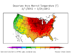
ACIS Climate Maps
Obtain precipitation, temperature, heating degree days, cooling degree days, and Standardized Precipitation Index maps on the national, regional, and state level with this tool.
A wide variety of products and services have been built using ACIS. By no means an exhaustive list, here is a sampling of products:
ACIS Climate Maps
Obtain precipitation, temperature, heating degree days, cooling degree days, and Standardized Precipitation Index maps on the national, regional, and state level with this tool.
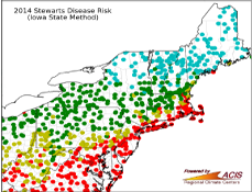
Stewart's Disease Risk
Discover the risk for Stewart's Disease of corn in the northeastern United States with this tool which is based on winter temperature data accessed via ACIS.
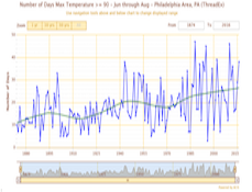
Climate Perspectives
This tool provides a regional look at temperature and precipitation as well as providing historical context. This tool is ideal for weather trivia and comparisons.
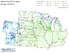
Frost Maps
This tool displays the date of the first fall freeze for a wide range of states spanning from Colorado and Wyoming in the west to Ohio and Kentucky in the east.
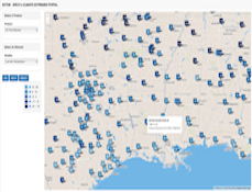
Climate Extremes Portal
Developed by the Southern Regional Climate Center, the Climate Extremes Portal graphically displays daily, monthly, and all-time temperature and precipitation records for weather stations throughout the United States.
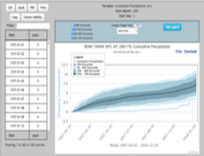
SC ACIS
This suite provides a variety of tools for summarizing and visualizing climatological data. Tables, graphs and maps can be created based on the ACIS daily, monthly and seasonal station and gridded datasets.
SCENIC
This platform was developed at the Western Regional Climate Center in support of the Southwest Climate Science Center. It serves as an access point for climate and remote sensing data and analysis tools.
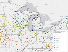
Snowfall Climatology
Developed by the Midwestern Regional Climate Center using ACIS, this snowfall climatology tool shows the average number of days certain amounts of snowfall occur at over 1800 stations nationwide.
Drought Atlas
Led by the National Drought Mitigation Center, this atlas uses ACIS to provide historical drought information so that decision makers can assess their risk to drought.
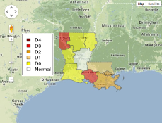
Southern U.S. Drought Tool
Developed by the Southern Regional Climate Center for the SCIPP RISA, this tool displays the severity of drought along with the amount of precipitation needed to break it.
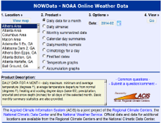
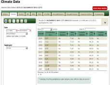
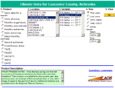
NOWData
Developed by the Northeast Regional Climate Center for use by the National Weather Service, users can obtain daily and monthly data in addition to extremes information.
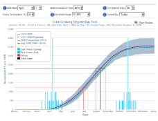
U2U Corn GDD Tool
Based off of gridded data available in ACIS-WS, this tool tracks real-time and historical growing degree day (GDD) accumulations and allows users to assess frost risk.
agACIS
Developed for use by the USDA NRCS, this tool helps field offices obtain daily and monthly data along with record extremes, frost/freeze dates, and growing degree day data.
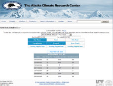
Alaska Data Browser
This data browser, developed by the Alaska Climate Research Center, shows daily data from sites in Alaska. Users may obtain temperature, precipitation, and degree day data.
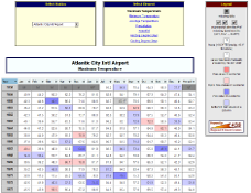
Historical Data for New Jersey
Developed by the Office of the New Jersey State Climatologist, this tool uses ACIS to provide monthly data for select stations in New Jersey as well as a nice visual of monthly extremes.
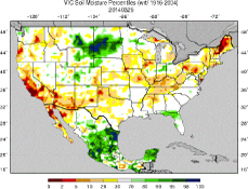
Soil Moisture Model
These modeled soil moisture maps from the University of Washington are developed using the Variable Infiltration Capacity Macro-scale Hydrological Model which uses ACIS.